Scott Trauner

Freelance writer and founding editor of The Connecticut Outdoor News (www.connecticutoutdoornews.com) "Either write something worth reading or do something worth writing." -Benjamin Franklin

My Photo
Name:
Location: Connecticut, United States

Sunday, June 25, 2006

Paddling to a "Great Place" in Cromwell

Standing shin-deep in mud, I had either been overeager or impatient or just plain skeptical that the tide could make that much of a difference here in the woods of Cromwell. Or maybe I was still baffled by how water this calm could have once powered a mill. I could even blame that great blue heron that had climbed into the air the moment before I mis-stepped on the cinder blocks of the ramp. Those two red-wings that flashed by were also kind of distracting. Either way, I was twenty miles inland from the Sound and three miles west of the Connecticut River, and I still almost lost a shoe while launching my kayak in the low water of the Mattabesset River.
But I had hoped for a little adventure on my trip to what the Nature Conservancy has called one of the "last great places of the Western Hemisphere."
With over 360 acres of wetland, the Cromwell Meadows Wildlife Management Area is one of the largest refuges in the lower Connecticut River watershed, and is an important habitat for a number of rare and endangered species, ranging from osprey to lamprey.
Despite the tide’s influence here, Cromwell Meadows is a freshwater habitat and is part of a larger system so unique that it has even gained global recognition. Thirty five years ago in Ramsar, Iran, countries concerned with protecting aquatic wildlife met for the first Convention on Wetlands of International Importance, Especially as Waterfowl Habitat. Simply known as Ramsar today, there are currently 1,550 sites recognized by this alliance, places like the Everglades, the Chesapeake Bay and our own Connecticut River Estuary and Tidal Wetlands Complex, which includes Cromwell Meadows.
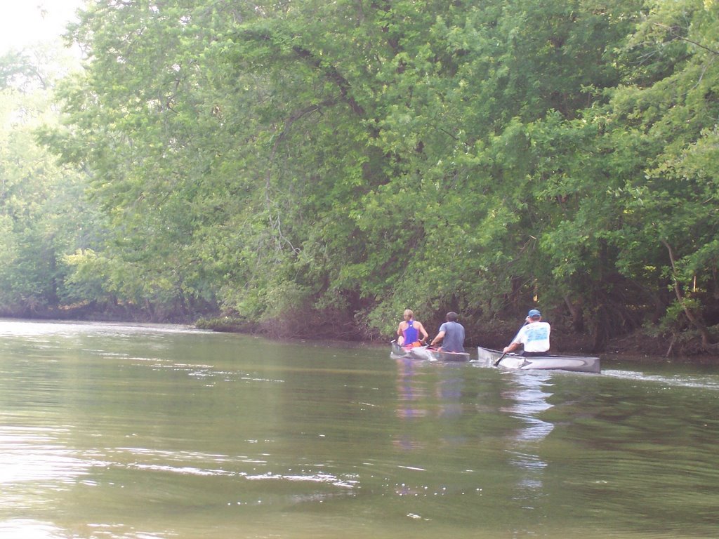
I shoved off behind the old Saw Mill Pub on Route 3, the beginning of the Mattabesset River Canoe and Kayak Trail. On the two-mile trip down river to Cromwell Meadows, I welcomed the respite that the woods offered from last Monday’s heat. Shafts of sunlight plunged to the bottom of the river, taking on the color of ale all the way down to the floor. This amber sediment is left churning from the tides and floods of spring that cut deep into the banks of the Mattabesset. Undermined trees hang on for years while apical dominance pulls them to angles that resemble elephant trunks in full blast.
Also, my pre-paddle bird encounters were no fluke. Large stick nests sit on these low-hanging limbs while dozens of nesting boxes and platforms rise along the river. Tree swallows, with their grackle-green capes, followed me the way gulls do a ferry while blue jays pressed subtle tracks into the mud. I hoped to see some mammals, too, but the only signs were the conically chewed stumps sticking from the banks like sharpened pencils.
Though cluttered with a lot of natural debris, the banks of the Mattabesset are clean, and despite the trees that have actually landed in the river, the water trail is free of portages. The Mattabesset River Watershed Association has been tending the water here for years. The main pollutants have been nonpoint- invisible ones like runoff from pavement- but I still noticed very little trash compared to one of my favorite waterways, the Quinnipiac River. At a cleanup there last year, I myself pulled nearly forty tires, some of them whitewalls, from its flood plain in Meriden, not to mention parts of cars that James Dean might have abandoned there himself.
Leaving the woods, the passage became hot and exposed, though the breeze was picking up off Boggy Meadow where the river widens. I was working a lot harder now to make any headway, the surface choppier in the bigger water of the meadows.
When the Arrigoni Bridge is visible, you know that the Connecticut River is just beyond the trees. The Appalachian Mountain Club’s canoe and kayak guide Quiet Water: Massachusetts, Connecticut & Rhode Island has paddlers starting the trip to Cromwell Meadows at Harbor Park on the Connecticut River in Middletown. By launching here at the terminus of the MRCKT, you will have a shorter distance to the refuge, but you may also have to endure some rougher water at the start. Because of this, Quiet Water suggests that paddlers always use a PFD here. Or, when the Connecticut is too rough, save the trip altogether for another day.
For my trip, I used two online guides to the Mattabesset: http://www.mrwa-ct.org/ and http://www.conservect.org)/ each offer downloadable brochures containing essential information on trip logistics, history, maps and possible wildlife sightings.
I myself was interested in seeing a green heron, which I had read about on one of these sites. Instead, I watched two swans as they skimmed effortlessly over the rippling water. I had stopped paddling except to steer and was waiting for the chance to photograph some birds at close range. I especially wanted a great blue heron to show itself up close. I had seen them all along my trip, flushing from the high grass, disappearing over the trees, then returning like a boomerang only to land where they took off in the first place. But because their silent flight contradicts their huge presence, I had to turn back without my shot.
Backtracking on a river lacks the repetition emblematic of an out-and-back hike. You’re less mobile in a boat, so your range of vision is limited and therefore some sights are kept for the way home. It’s a whole new experience when you’re returning. Wind shifts, sunlight fades and tides rise and fall. I’ll have to keep the latter in mind for next time.

Saturday, June 17, 2006

Despite Challenges, East Coast Greenway Will Be Worth The Wait

I recently read an old National Geographic story about cowboy artist C.M. Russell and found that his beliefs on the environment were just as interesting as the famous Western imagery he painted nearly a century ago. Reacting to the rise of the automobile, Russell seemed to prophesize today’s gas crisis, saying that "skunk-wagons" should only be used if you need a doctor; otherwise, take a horse.
Russell would have loved today’s ongoing pursuit of defunct railroads for commuting alternatives and recreation, and had he heard about a 3,000-mile path linking all the major cities on the East Coast, the Montanan might even have traded in his horse for a bike.
Leading the project that some people call an "urban Appalachian Trail" is the East Coast Greenway Alliance based in Warwick, Rhode Island (www.greenway.org). Since 1991, the ECGA has been encouraging folks to leave their cars home and to take advantage of the many linear parks they hope will someday run continuously from the Canadian border at Calais, Maine to the southernmost point of the country in Key West Florida.
Like the Appalachian Trail, though, the ECG’s initial progress has been stop and go, but with time it can become just as cherished as its sister in the hills.
Imagine that star-struck feeling you get when meeting through-hikers in the Northwest corner of Connecticut. Maybe they’re from California, or even Europe, and everything they need for their 2,175-mile journey is hefted onto their backs. Travelers on the ECG will have that same aura, all their essentials stuffed in panniers, pedaling through the flat rail beds of New England down to the sandy tropics.
That’s a long way off. While the ECGA has sketched an interim route consisting of public roads and existing linear trails, just 21% of the current path is out of the traffic and smog. Still, the ECGA estimates that 80% of the greenway will be completed by 2010.
But even in places already designated for the ECG, it has been tough to break ground. In 1998, for instance, the towns of Cheshire and Southington chipped in with the Department of Environmental Protection to buy a nine and a half-mile strip of land from the Boston and Maine Railroad. Eight years later, that land has not been developed.
The slow going is no fault of the trail’s stewards. The challenges that the ECGA face today are tenfold compared to what the Appalachian Trail Conference faced in the 1920's and 30's. From funding to logistics, trying to thread a paved bike path through the entire megalopitan East Coast is quite an undertaking.
Much of the proposed greenway is made up of already existing paths left over from Ninteenth Century railroads and canals. These are the very features that make our state’s greenways so fascinating, but connecting these different routes tacks on a lot of extra mileage. In other words, the ECG is not a straight line. Connecticut’s 195-mile portion of the proposed trail begins at the Rhode Island border and zigzags before it meets up with the relatively straight north-to-south Farmington Canal. The state’s interim route is 234 miles. Such meandering makes the trip from Calais to Key West nearly 3,000 miles instead of the 2,000 you would drive between these points.
From a recreational point of view, the more miles the better. We get a wide variety of surroundings, from urban to coastal. But from the standpoint of the non-profits and municipalities that plan and develop these sites, miles mean money and generating money takes time. That land in Cheshire and Southington, for example, cost 1.42 million dollars. That, of course, does not include the thousands of dollars more that are needed for bridges, pavement and signage.
Grants have been the main source of funding for these linear parks. Last October, $670,000 in federal grants was distributed to over thirty trail projects in the state. Only two of these projects, however, are directly on the route of the ECG. The Hop River State Park Trail in Bolton received over $8,000 for improvements and over $2,000 was slated to upgrade the Air Line State Park Trail in Colchester.
According to the ECGA’s 2006 "Blueprint for Action," however, these two recipients may actually lose ECG designation if their trails are not finished this year. The report also said that the greenway planned to run parallel to the Merritt Parkway has not received sufficient attention from the Department of Transportation, while the route between Hartford and Simsbury also needs more support from the State.
As much of a challenge filling these gaps poses, a ride last week on the Farmington Canal Greenway in Cheshire and Hamden (www.farmingtoncanal.org) highlighted why these issues should be endured, and displayed that the ECGA is certainly making headway.
This eight-mile route is one of the most established greenways in the state, offering its users the best in historical significance, natural surroundings and fitness opportunities.
Starting at the parking area on Cornwall Avenue in Cheshire, I headed south toward Hamden. After just two miles, I reached Lock 12 Historical Park, the only restored lock on the Farmington Canal today. Between 1828 and 1848, goods as well as passengers were transported to and from New Haven. Just from Cheshire, the trip took up to five hours as mules towed the flat-bottomed boats along the channels. These channels are still visible all along the greenway, some dry, some boggy, some crystal clear.
Crossing into Hamden, modern evidence of commerce lines the trail, as signs of area businesses advertise pizza slices and cold drinks. Like through-hikers on the Appalachian Trail, long-distance cyclists would also bring money to communities along the way. A typical through-hiker spends between three and five thousand dollars for the trip. But they essentially sleep for free. With few places for cyclists to camp, business at restaurants and hotels would especially pick up.
There are other diversions, too, including the chance to create your own biathlon with the many hiking trails that flank the greenway. Just a quarter mile into Hamden, Brooksvale Park has over seven miles of hiking trails, while a short distance more will bring you to West Woods Road in Hamden, five miles from your car, where a right will bring you north on the blue-blazed Quinnipiac Trail and a left down Mt. Carmel Avenue will bring you to Sleeping Giant State Park just a quarter mile away.
Such destinations will be available all along the completed ECG, from historic battlegrounds to hot beaches. This sounds ambitious, but it 1921, when Benton MacKaye proposed a hiking trail running from Georgia to Maine, he probably felt more than a few strange looks settle upon him. Sixteen years later, however, when the Appalachian Trail was completed, he probably felt even more looks of admiration.
With a little more time and support, the ECGA will know that feeling, too.

Saturday, June 10, 2006

Keeping Their Balance on Ragged Mountain

All week, I had been looking forward to using a grip hoist, a combination of cable and crank that can move stones weighing up to two tons. There were several of them, too, fastened to old backpacks that had been stripped down to their aluminum frames. Unfortunately, they’d never make it onto our shoulders, or to the trails we had planned to work on last Saturday morning.
Gary St. Amand has led trail maintenance parties like this for years here in Connecticut’s premiere rock climbing area, and while the heavy rain of last weekend cancelled this National Trails Day event, he and several other members of the Ragged Mountain Foundation took me on a tour of the group’s fifty-six-acre preserve in Southington.
A founding member and former Director of this nonprofit land trust, St. Amand has been a true pioneer in Connecticut conservation. The RMF was the first rock climbing group in the country to gain ownership of a climbing area. Since then, the RMF’s effort has gained momentum, even as they juggle hands-on activities like trail work and clean-up with sensitive community issues like parking and access.
With its large membership of responsible hikers and climbers, the RMF is an asset to this area. Today’s group in particular brought its collective experience and credentials to this Trails Day effort. John Rek, for example, is also a member of the New Haven Hiking Club and the Connecticut Climbers and Mountaineers and regularly maintains the stretch of the Metacomet Trail between Route 364 and the Berlin Turnpike. St. Amand himself, aside from leading the day’s work, is one of many health professionals in the RMF. Chuck Boyd, board member of the RMF and co-chair of its Property Management Committee, brings to these cliffs the experience of having summited Mount Everest in 2004.
Despite such credentials, there are those visitors to Ragged Mountain who mar the image of responsible rock climbers. Neighbors I spoke with last week were concerned with a variety of issues that surround Ragged Mountain, including street congestion, climbers changing clothes in plain view of their homes, litter and displaced wildlife.
Meanwhile, the ongoing disagreement regarding a possible parking area nearby was also evident. One neighbor welcomed it, while another worried that it would attract an unwanted element to the area, citing instances of teen drug and alcohol use on the property. Last September, a number of Andrews Street residents successfully petitioned the Southington Town Council to abandon a plan for public parking. A call to the Southington Town Manager’s Office last week concluded that there are no current plans for designating a lot.
The RMF understands the neighbors’ concerns and hopes to work towards sharing the area in a cooperative manner.
"Ragged stands as a classic example of the need to balance recreational use and the concerns of neighbors," said St. Amand. "I feel for the neighbors and would not want people parking in front of my house leaving litter and making noise."
He does, however, believe that the RMF can help alleviate these concerns.
"On the other hand, I’ve always felt that, when properly managed, an area like Ragged Mountain can be an asset to a community, and not a liability," St. Amand said.
My firsthand look at the RMF’s work began on Sheldon Street, the mainstage for many of these concerns. After just fifteen minutes through the woods, I soon understood the attraction; these cliffs beg to be climbed.
With approximately 200 climbing routes on the face of Ragged Mountain, the trail below is surprisingly spotless, while on each side of the promontory are beautiful traprock staircases the RMF has constructed. Basalt water bars diverted the day’s downpours as the steps zig-zag to the 761-foot summit.
Such an environment doesn’t happen by accident. And, unfortunately, not without hardship, either. Early in the RMF’s existence, after investing thousands of dollars and hours of physical work, chainlink gabions installed by volunteers were purposely destroyed. St. Amand says that this vandalism only strengthened the group’s dedication to its mission of "public access to Connecticut’s high and wild places." Now the group only uses the traprock of Ragged Mountain itself for trail work, each individual step a monument to the perseverance of the RMF.
People have been coming to Ragged Mountain to climb for over sixty years, and as the sport only grows in popularity, they will continue to come here, which is why the RMF’s presence is important for all stakeholders.
Other than Sheldon Street, the closest public parking to Ragged Mountain is at Timberlin Park. To see how realistic Timberlin is as an access point, I parked here last Tuesday and picked up the Metacomet Trail just a short distance from the circle. While the hike up the 520-foot Short Mountain is not necessarily a difficult one in itself, it does expend time and energy that I imagine climbers would rather be using on the rock face.
A half hour from Timberlin, already twice the time from Sheldon Street, the descent is a quick but rough one and a load of climbing gear on your back wouldn’t make it any easier. Forty minutes into my hike, I reached Carey Street and the four No Parking signs installed where climbers’ cars once lined the road.
I continued uphill on the Metacomet. If Short Mountain doesn’t faze your legs, the incline to Small Cliff might. The blue trail has you scrambling up boulders to its merge with the Ragged Mountain Preserve Trail, the blue and red-blazed path to the right that creates a six-mile loop with the Metacomet. At this junction, I took a left down the Metacomet only to head back up to the summit of Ragged Mountain.
This time, however, it took nearly an hour to get here. I understood the parking conflict whole a lot better now and I hadn’t even been to Ragged Mountain on a sunny day yet. On a nice weekend afternoon, you can find between twenty-five and thirty climbers from all over the region at Ragged Mountain.
Despite the drizzle, Jake Feintzeig made the hour-long trip from Fairfield because he says it’s the best spot in the state. As the Dartmouth College student belayed his friend somewhere down below on the route known as Broadway, he told me about his summer internship with the Park Service in Washington State. Before heading out west in a few days, he decided to spend some time at Ragged Mountain.
That says a lot about this place and the people who love it. Take a walk around here, though, and you can see it written in stone.

Sunday, June 04, 2006

A Hike to Remember in American Legion State Forest

I thought of my grandfather while hiking through American Legion State Forest last Sunday. He never told me much about his service in World War Two, but I had read enough of his letters to picture tree limbs shattering above him in the Ardennes Forest. What a contrast to the peaceful canopy hanging above me that Memorial Day weekend.
You can even hear in my grandfather’s words just how unsure he was about ever getting back home: "Someday again soon maybe I shall enjoy wonderful America. It seems so far off though."
He wrote this in a V-Mail to my grandmother in February of 1945. He had been wounded twice in the Battle of the Bulge, a conflict that claimed 81,000 Americans. It’s no wonder he had such doubt.
Ironically, this public forest in Barkhamsted is modeled after places like the Ardennes. According to the Department of Environmental Protection, the first 213 acres of the forest were donated by the American Legion in 1927, just eight years after the organization was chartered. Soldiers who had served in Europe during World War One had been so impressed by the forests there that they wanted to create such a refuge here in Connecticut.
And while these soldiers of the past designated this refuge, it was one particular active soldier who inspired me to go there last week.
Two weeks ago, HBO aired a documentary called Baghdad ER. It’s a graphic film showing the challenges faced at the 86th Combat Support Hospital in Iraq. I watched it with a friend of mine who returned from the war in October.
An experienced hiker, climber and paddler, this friend has taught me a lot about the outdoors in the several years I’ve known him, but sitting with him during this one-hour show taught me more than I ever imagined.
Between scenes of courageous doctors working to save severely wounded soldiers, he pointed out Baghdad landmarks he had become accustomed to seeing each day. He even recognized one soldier’s face. This friend helped make a very distant war into a very local one, and moved me to find a way to reflect on those Americans who have sacrificed themselves.
While reading up on the forest that has since grown to 782 acres, I found an article on the American Legion’s web site called "Take Back Memorial Day" by Christopher Michel. The former Naval Flight Officer writes of his concern that the holiday’s "quiet reverence has slowly been lost to the noise of commerce and the American pursuit of recreation."
My hike, however, was to be more about reverence than recreation, as it would be through the woods that only exist today because of soldiers who served our country nearly a century ago. Many of the veterans who proposed this public forest would later construct and maintain it as workers in Roosevelt’s Civilian Conservation Corps in the 1930's. This New Deal program was intended to conserve forests, but it was also a way to rebuild the spirit of the young and jobless generation of the Great Depression. The CCC was militaristic in nature and was especially active here in Connecticut. During the mid-Thirties, there were twenty-one CCC camps in the state, including sites in Middletown, Haddam, Portland and East Hampton. Over three million young Americans served in the CCC, planting trees, building dams and constructing footpaths.
The Henry Buck Trail is a great example of their work. One of only two footpaths in the American Legion State Forest, this 2.1-mile trail begins and ends on West River Road in Pleasant Valley. Cutting through dense growth are beautifully constructed stairways, taking hikers to a plaque commemorating the trail’s namesake and the CCC workers that completed its construction in May 1935.
On Memorial Day in 1993, the North East States Civilian Conservation Corps Museum officially opened in Stafford Springs. The site was once a CCC camp itself and now contains photos of state projects as well as tools for tree planting, forest cleaning and logging that were used to construct walking paths like the Henry Buck Trail.
I picked up this blue-blazed path near a ruined dam on the Farmington River, a recreational gem in itself that the National Park Service has designated as "Wild and Scenic." The sound of its water splashing through the ruins soon merged with the rushing streams in the forest. Ferns flashed with the green life of spring while red efts relaxed on mossy stones in the middle of the trail.
Again, the peace of the forest allowed me to reflect on more hostile places. I especially thought of my friend pointing out Route Irish in the film. This 7.5-mile highway running between the Green Zone and Baghdad International Airport is sometimes called the most dangerous road in the world. It has been the site of hundreds of deaths in the past four years.
With so many risking their lives on this highway each day, it’d be an insult not to consider them while driving on American Legion Road. This 1.6-mile dirt path is open to cars and takes you past beaver dams in which you would expect to see moose if you were just a little further north. Drive or walk 1.5 miles into the forest and you will see another blue-blazed trail on the left. A ten-minute walk here brings you to Turkey Vulture Ledges, which offers scenic views of neighboring People’s State Forest and its many more miles of trails.
But whatever American Legion State Forest lacks in trails, it makes up for it with history and the opportunity to reflect on those who have contributed to that history.
Leaving the forest, I thought about the only war story my grandfather ever told me. He and his buddies had made camp in a barn when the farmer who owned it walked in and waved to them. That was his story. No blood. No gore. It simply blew his mind that this farmer had become so used to having a war fought in his backyard.
Hiking in forests like American Legion, I’ve only known peaceful places. And that’s a good thing, as long as we remember why they are so peaceful.

Friday, June 02, 2006

A Proud Day for Connecticut Trails

If you took Connecticut’s entire system of blue-blazed hiking trails and straightened it out into one continuous line, you’d be able to walk from downtown Hartford all the way to the shore of Lake Michigan. Tack on the spectrum of other blazes here and who knows where it could bring you.
That’s a lot of trail raveled up in our little state, but then again, we’re a state that loves its trails. This weekend, we’ll show the rest of the country just how much.
Saturday, June 3rd is National Trails Day, a celebration of the footpaths leading us to health, peace and a better understanding of our natural world.
Although Trails Day is celebrated throughout all fifty States, Puerto Rico, Guam, the U.S. Virgin Islands and Canada, our "little state" led the pack in 2005.
"Connecticut had the most events in the nation last year," said Adam Moore, Executive Director of the Connecticut Forest and Park Association. "Roughly ten percent of all Trails Day events in the nation were held in our
state."
According to the CFPA, the state coordinator for Trails Day, Connecticut will again lead the nation with over125 events. The complete and updated schedule is available online at http://www.ctwoodlands.org./ From hiking and biking to birding and trail maintenance, 86 communities all over the state have some activity registered with the CFPA.
Moore attributes this high participation to the state’s large population of outdoor enthusiasts and the wealth of natural resources in which they live and play.
"We have so many people living in such close proximity to the outdoors," said Moore. "All of the communities in Connecticut, in particular the urban communities, have an extensive system of trails, parks and open spaces just out the front door."
Not only are the resources there, but so is the interest. According to the Department of Environmental Protection’s Statewide Comprehensive Outdoor Recreation Plan (SCORP), 86% of state households and 72% of state individuals either walk, run or hike as a recreational activity.
But even if these figures don’t reflect your daily routine, this weekend will provide plenty of opportunity to try something new.
"Participating in a Trails Day event is a great way to start," said Moore. "They are scattered across the state, so you can pick one in your neighborhood or go to a part of Connecticut that you have not seen before."
Central Connecticut will be especially busy this weekend. Hikes for all abilities are scheduled in Berlin, Newington, Rocky Hill, Middlefield and Middletown, while the Whethersfield/Rocky Hill Heritage Bicycle Path will see its Grand Opening. In addition, the Connecticut Chapter of the Appalachian Mountain Club has a flatwater paddle slated for the Mattabesett River in Cromwell.
After the busy day in the woods, Northeast Utilities in Berlin will host the Trails Day Potluck Dinner, where Gary St. Amand of the State Department of Health will be the featured speaker. St. Amand, an experienced hiker, climber and paddler himself, works in the Department’s Heart Disease and Stroke Prevention Program and sees a direct link between getting outside and overall health.
"We definitely support physical activity and the attention that Trails Day draws to it," said St. Amand. "What I like about hiking is that pretty much anybody can do it. You just need to get out and walk. It’s the easiest form of exercise there is."
Like Moore, St. Amand also believes that hiking in Connecticut is especially convenient.
"I like that it’s so accessible," he said. "You really don’t have to go very far to find a hiking trail."
St. Amand, whose presentation is called "Trails and Public Health," has been doing lectures on the topic for six years.
And he practices what he preaches, too. The fifty year-old from Newington rides his bike to work each day in Hartford, while his two dogs keep him busy walking both on and off the trails.
Another major theme of Trails Day is that responsible recreation leads to preservation, something St. Amand is certainly familiar with. St. Amand has led trail maintenance projects at Ragged Mountain in Berlin for years. He will be leading a group there Saturday to work on erosion control and welcomes all to join him.
"We need volunteers," he said.
If trail work doesn’t sound exciting to you, a few hours with St. Amand may change your mind.
"We’re going to be using specialized tools called griphoists," he explained. "We can move rocks up to two tons. We carry all of our equipment in our backpacks."
A former Director of the Ragged Mountain Foundation, St. Amand and his fellow outdoorsmen pioneered the conservation of this popular hiking and climbing spot.
"We were the first group of rock climbers to acquire a major rock climbing area in the country," said St. Amand. "The area has been used recreationally for sixty years, but no one had really maintained the trails there."
The RMF changed that seventeen years ago and their legacy is literally preserved in the stones they work with.
"We started in 1989 using basalt rock to build and maintain the trails," said St. Amand. "All our work there is done in stone. We’re very proud of that."
There are many groups contributing to Trails Day in a number of ways. From land trusts to corporate sponsors like Tilcon and Connecticut Water, the community at large has responded to the importance of this event.
In addition, the DEP’s Parks Division has waived parking fees so all residents, regardless of their economic situation, can celebrate the trails around them. Just last week, Governor Jodi Rell announced that Bank of America donated $10,000 to the state’s No Child Left Inside initiative, a gift that will provide 2,500 foster families with free season passes to Connecticut’s state parks.
The CFPA has also been working to reach more residents through its WalkConnecticut program. This initiative is meant "to introduce all citizens to the joys of outdoor recreation through walking and learning, in order to promote a lifelong connection with the land." From developing Braille walks to encouraging people of all backgrounds and ages, the CFPA has been a leader in promoting healthy lifestyles through the use of trails. In this same spirit, the CFPA will lead a walk this Saturday through the wheelchair-accessible John R. Camp Demonstration Forest in Middlefield.
"By no means are the events all long-distance, strenuous hikes," said Moore. "There is a wide variety of activities to choose from. Some are suitable for those in wheelchairs and those pushing strollers. Others are family hikes geared towards children."
Whatever category you fall into, the tangle of trails here in Connecticut leaves you with many options. You may not end up at Lake Michigan, but we have our own wonders to be proud of. This Saturday, discover some for yourself.